|
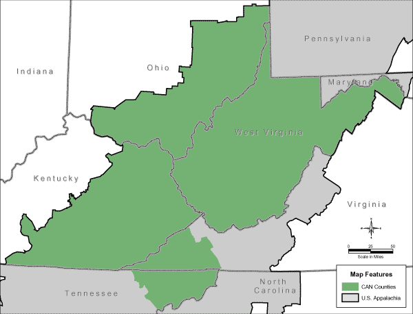
CAN (Central Appalachian Network) Region
Maps
(Note: This is part of the nationwide map of The Wildlands Project,
although it is carefully couched in extreme Language Deception.)
http://www.cannetwork.org/about/map.php
Additional researched, recommended
reading:
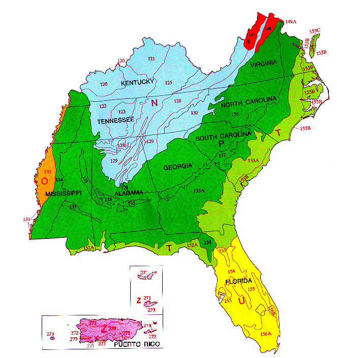
Major Land Resource Areas in MO-15:
The capital letters on the map indicate Land Resource
Regions. The numbers on the map indicate Major Land Resource Areas. A
Major Land Resource Area is a geographic area, usually several thousand
acres in extent, that is characterized by a particular pattern of soils,
climate, water resources, land uses, and type of farming. A complete
description of of each Land Resource Region and each MLRA
is available at http://soils.usda.gov/survey/geography/mlra/.
![[The letter N, which refers to a region on the map.]](../../2005/pics/can.ht7.gif) East
and Central Farming Forest East
and Central Farming Forest
- 120 Kentucky and Indiana Sandstone and Shale Hills and Valleys
- 121 Kentucky Bluegrass
- 122 Highland Rim and Pennyroyal
- 123 Nashville Basin 125 Cumberland Plateau and Mountains
- 128 Southern Appalachian Ridges and Valleys
- 129 Sand Mountain
- 130 Blue Ridge
Mississippi
Delta Cotton and Feed Grains
- 131 Southern Mississippi valley Alluvium
South
Atlantic & Gulf Slope Cash Crops, Forest and Livestock
- 133A Southern Coastal Plain
- 134 Southern Mississippi Valley Silty Uplands
- 135 Alabama, Mississippi and Arkansas Blackland Prairies
- 136 Southern Piedmont
- 137 Carolina and Georgia Sandhills
- 138 North Central Florida Ridge
North
Atlantic and Gulf Slope Diversified Farming
- 147 Northern Appalachian Ridges and Valleys
- 148 Northern Piedmont
- 149A Northern Coastal Plain
Atlantic
and Gulf Coast Lowland Forest and Crop
- 151 Gulf Coast Marsh
- 152A Atlantic Coast Flatwoods
- 153A Atlantic Coast Flatwoods
- 153B Tidewater Area
- 153C Mid-Atlantic
![[The letter U, which refers to a region on the map.]](../../2005/pics/can.ht12.gif) Florida
Subtropical Fruit, Truck Crop, and Range Florida
Subtropical Fruit, Truck Crop, and Range
- 154 South Central Florida Ridge
- 155 Southern Florida Flatwoods
- 156A Florida Everglades and Associated Areas
- 156B Southern Florida Lowlands
![[The letter Z, which refers to a region on the map.]](../../2005/pics/can.ht13.gif) Caribbean
Region Caribbean
Region
- 270 Humid Mountains and Valleys
- 271 Semiarid Mountains and Valleys
- 272 Humid Coastal Plains
- 273 Semiarid Coastal Plains
http://www.mo15.nrcs.usda.gov/about/images/mlras_se.gif
http://www.mo15.nrcs.usda.gov/about/mlras_in_se.html
This is the national map, but is not currently accessible:
http://soils.usda.gov/soil_survey/geography/mlra/main.htm |
